| On August 29th 2005, a category 5 hurricane approached the Gulf
coast, reducing to category 4 as it made landfall. It was a huge storm over
140 miles wide. The eye missed New Orleans and hit near Gulfport just over
the Mississippi border about 50 miles to the east. The winds were gusting
around 135mph and caused significant structural damage. The advisory
warnings suggested extensive damage to almost all buildings. New Orleans
largely survived the hurricane, most houses in the east of the city (the
poorer area) had roof and window damage. There was a storm surge which in
places was higher than the levees and there was some flooding. 80% of New
Orleans (144 sq miles) is below sea level. The levees are at most 17ft above sea level and
the storm surge for category 5 is around 28ft.
The damage as Katrina left was extensive but probably not catastrophic. | 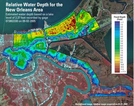 |
 | As night fell,
the reports went out about survival. Some of the levees had been overtopped
and the water had weakened them by scouring the foundations. In addition
some barges had collided with canal walls and caused more weakening. Over
the next 24 hrs the levees suffered five major failures and numerous smaller
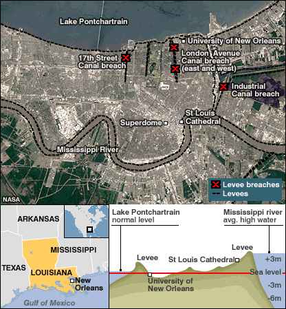
ones. In a matter of hours half a BILLION cubic metres of water flooded various
parts of New Orleans as shown above. The Industrial Canal breach flooded the
lower 9th ward (a very poor area) and a disaster became a catastrophe. These
breaches were more than two city blocks wide. Attempts to plug the gaps with
sandbags took a week to stop the water flow and the pumps which would pump
out the water failed and took days to repair. It took almost two months to
get the water out. The damage went from maybe $1 billion to the current
forecast of $26 billion. 1,622 officially died but over 4,000 are still
missing. |
| The red areas were all flooded, mainly from Lake Pontchartrain to
the north.
Houses (built mostly of wood) which have water in for more than two weeks are almost certain to
have to be demolished. In the main this was salt water which only made
things worse. | 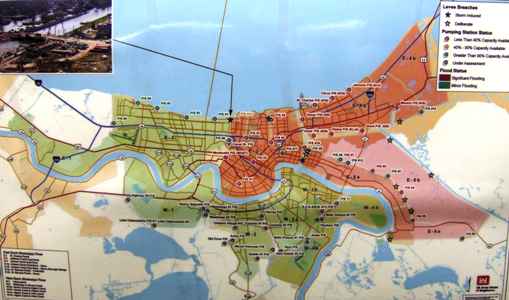 |
 | Here you can see
one of the breaches. We were told that a house had been built on top of the levee
at this point and the owner had removed some mature trees which had
destabilized the soil. I can't be certain but it isn't there now. There were
many houses washed off their foundations. |
| Attempts were made to evacuate the city (over 1 million people) but many
had no transport or wouldn't leave. Many moved here to the Superdome.
Afterwards many more came here but there was little food, water or
sanitation, or organisation. This became a disaster zone in its own right. | 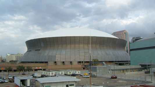 |
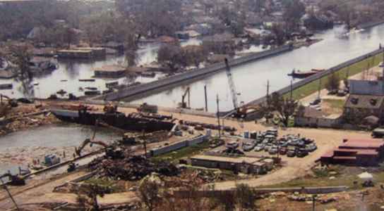
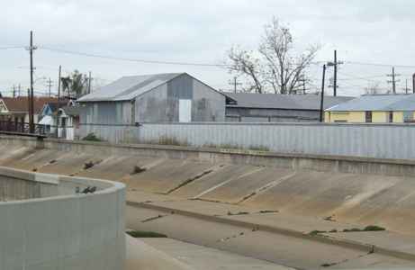 | This is one of
the canals, largely intended as a drain for storm water to be pumped out of
the city. But in the hurricane they became channels for the storm surge to
travel into the city. |
| The pump stations are quite massive and there are several in each
section. But parts failed and replacements had to be manufactured since they
are no longer made, so much time was lost. | 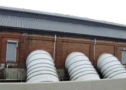 |
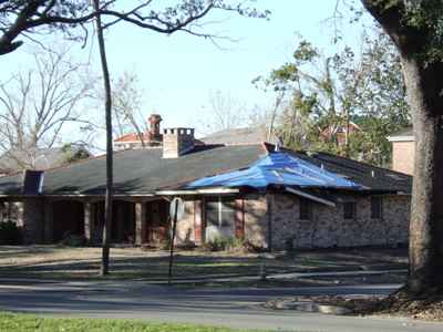
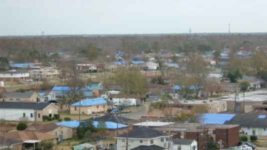 | The city is still
in 'relief' mode and has a long way to go before they can start
reconstruction and five months have already passed. The blue roofs are tarpaulins
covering damaged roofs to try to prevent further damage from wind and rain. As you can see, in this
area, every other house has one. A hurricane is more dangerous on its
eastern side and Katrina passed to the east of New Orleans so they were
spared the worst. |
| The road above is the I10 interstate but all the cars underneath
are flood damaged and thus worthless. There are just thousands of them and
nobody has started to dispose of them yet. | 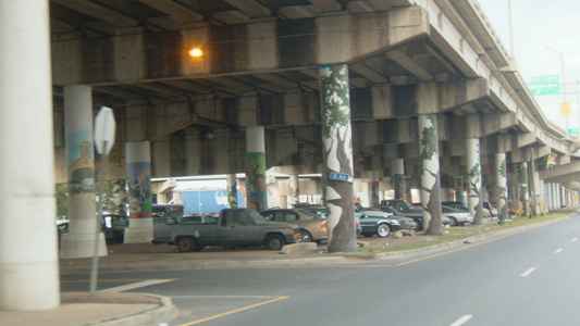 |
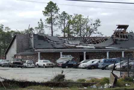
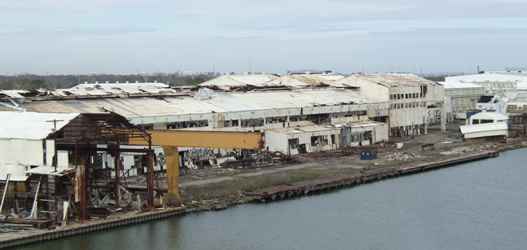 | Industry survived
no better. This factory has much of its roof and side walls just blown away.
Few businesses are working yet, in many cases because they have no workers.
The city population is now estimated at under 200,000. |
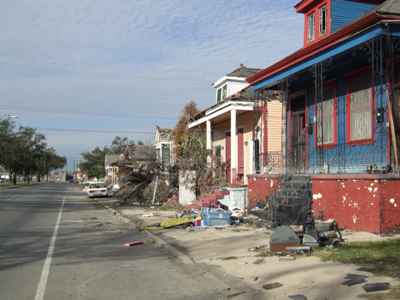
| This is in one of the more prosperous districts. It is a solid
substantial building but has lost some roof sections and several windows and
it will have suffered some flooding. There was no sign of occupation visible
as we stood waiting outside it for a bus. | 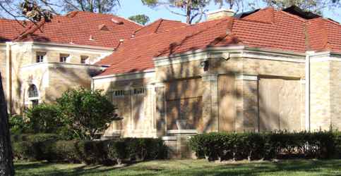 |
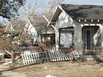
 | This is the
house next door and in similar condition. These houses still have structural
integrity and so are better off than some even on the same road. Few seem to
be inhabited. The owners are probably still arguing with the insurance
companies. Flood insurance is optional in the US and unaffordable in some
parts. The insurance companies are claiming the damage is from flood and not
from wind. It all becomes a game with insurance, state and federal
authorities all arguing somebody else should pay. Many families are wiped
out, even undamaged properties are now worth so much less than they were.
Negative equity will be an issue for some for years. |
| Across the road there are still portaloos, a reminder that many
infrastructure services are still not functional here. As you can see about
80% of the city's traffic lights are not working. Another 6 months and $30
million are needed just for that. | 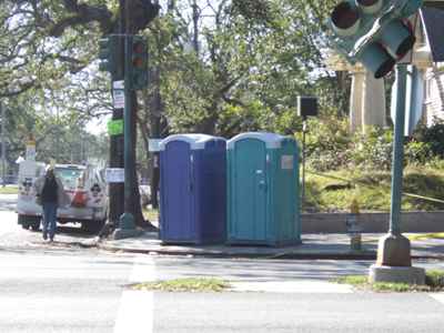 |
 | As you move
eastwards through the city, the damage gets worse. I don't think a blue tarpaulin
is going
to help here. The damaged roof went somewhere, often crushing a car or a
boat, which is still there. We drove past motels with piles of fridges and
TVs dumped on the roadside, just waiting for disposal. |
| Even brick walls were just washed out with the flood waters. It
seems unbelievable in an area which is now dry, but at their peak the waters
here were ten feet deep. We found street after street where all you could
really do is bulldoze the lot. But the residents are fighting this. | 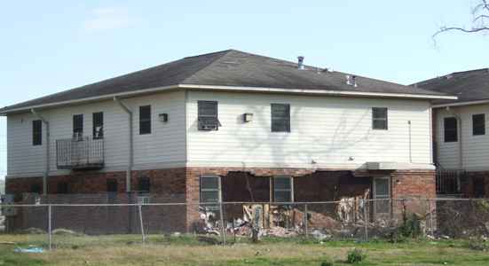 |
 | The quality of
the housing wasn't good to begin with. The photos on a sunny day make it
look a lot better than it is. These are better than some but the gardens
are still full of wrecked cars, trees, furniture and just masses of debris. |
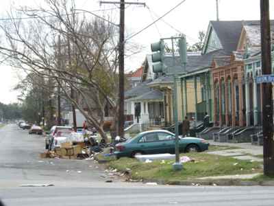
| Some people have started to gut the houses and move everything
outside to the verges where it sits in the median (central reservation) or at the roadside until a
truck comes to collect it. But we are talking about millions of tons of
debris, and where are they going to put it all? | 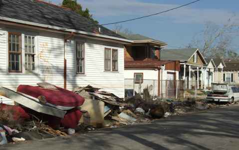 |
 | It is just
endless. You cannot see how this city is going to put itself back together.
As you listen to the news it is a constant set of accusations of
incompetence and blame. It really comes down to sheer inadequacy of public
officials and systems to cope with needs on this scale. They are talking
about rebuilding the levees to withstand a category 5 hurricane. The Corps
of Engineers (Army) are working to restore the integrity of the current system
by the time the next hurricane season starts in June. They don't seem to grasp that raising
the 200 miles of levees another 15ft is not a practical proposition in the
foreseeable future.
They have only just paid a visit to Holland to ask the Dutch how to manage
things. |
| A lot of the damage was caused by falling trees and although the
main roads are now clear, many side roads are not and many houses have
problems as here. Removing these is not a five minute job but requires
specialist skills and equipment. | 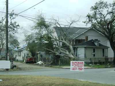 |
 | Because the water
table is so high, most cables are above ground on poles. The damage to these
is extensive and only jury rigged repairs have been done in most places.
Cables underground have been damaged by prolonged exposure to salt water, so
an almost complete cable replacement is needed. Most of the houses on this
road require demolition in my view. But these aren't in the areas scheduled for
demolition. We did not dare to venture into those areas. |
| Even the Garden District was not immune. We saw this house having
some of its roof replaced, and it was not alone. In order to repair or
rebuild your house, you need permission. If your house is at or above the
base flood level then permission will be granted. If it is below then you
can only repair if the damage is less than 50% of market value. If you
rebuild it must be raised to base flood level or higher. New flood area maps
will be released soon and are likely to be worse. Thus many residents are
trying to insist their houses are less damaged than they really are since
building higher will be much more expensive.
The potential for corruption is significant! | 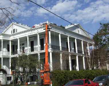 |
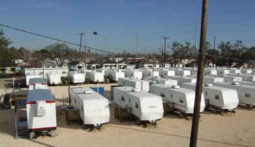 | We have heard a
lot about the number of FEMA trailers which have been provided as temporary
housing. We saw some
evidence of that but more evidence of trailers waiting to be installed. The
problem appears to be they can get the trailers but they can't set them up
with water, electric and sewage connections. So they remain empty. There aren't enough
workers, but Louisiana won't allow non-local workers in, and they have no
accommodation. Chicken and egg. |
| Some houses now have trailers in the yard, but many houses in the
poorer areas don't have big enough yards. Those who are in authority keep
saying it is somebody else's job. There is a real lack of leadership. It
seems to be that nobody trusts anybody else and the state/federal arguments
are just getting in the way. It needs a JFDI style army general in charge
but politics won't allow it. | 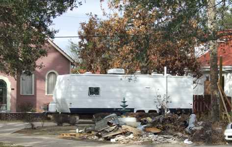 |
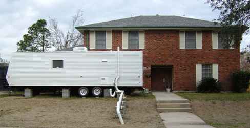 | It almost looked
as though you had to have clout to get a trailer. But I don't know the
circumstances of this family. |
| All we did see was thousands of trucks with built-up containers
hauling masses of debris - somewhere. Given the progress they appear to
have made in the last five months, they will still be doing this in another
eighteen months. This city is never going to be the same again, even if it
does become the 'Chocolate' city the mayor Ray Nagen says that God always
intended it to be. | 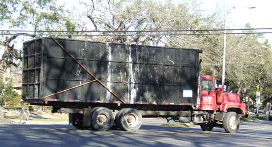 |
One of the warnings issued by the National
Weather Service in New Orleans before the storm hit:
URGENT - WEATHER
MESSAGE
NATIONAL WEATHER SERVICE NEW ORLEANS LA
1011 AM CDT SUN AUG 28 2005
...DEVASTATING DAMAGE EXPECTED...
HURRICANE KATRINA...A MOST POWERFUL
HURRICANE WITH UNPRECEDENTED
STRENGTH...RIVALING THE INTENSITY OF HURRICANE CAMILLE OF 1969.
MOST OF THE AREA WILL BE
UNINHABITABLE FOR WEEKS...PERHAPS LONGER. AT
LEAST ONE HALF OF WELL CONSTRUCTED HOMES WILL HAVE ROOF AND WALL
FAILURE. ALL GABLED ROOFS WILL FAIL...LEAVING THOSE HOMES SEVERELY
DAMAGED OR DESTROYED.
THE MAJORITY OF INDUSTRIAL BUILDINGS
WILL BECOME NON FUNCTIONAL.
PARTIAL TO COMPLETE WALL AND ROOF FAILURE IS EXPECTED. ALL WOOD
FRAMED LOW RISING APARTMENT BUILDINGS WILL BE DESTROYED. CONCRETE
BLOCK LOW RISE APARTMENTS WILL SUSTAIN MAJOR DAMAGE...INCLUDING SOME
WALL AND ROOF FAILURE.
HIGH RISE OFFICE AND APARTMENT
BUILDINGS WILL SWAY DANGEROUSLY...A
FEW TO THE POINT OF TOTAL COLLAPSE. ALL WINDOWS WILL BLOW OUT.
AIRBORNE DEBRIS WILL BE
WIDESPREAD...AND MAY INCLUDE HEAVY ITEMS SUCH
AS HOUSEHOLD APPLIANCES AND EVEN LIGHT VEHICLES. SPORT UTILITY
VEHICLES AND LIGHT TRUCKS WILL BE MOVED. THE BLOWN DEBRIS WILL CREATE
ADDITIONAL DESTRUCTION. PERSONS...PETS...AND LIVESTOCK EXPOSED TO THE
WINDS WILL FACE CERTAIN DEATH IF STRUCK.
POWER OUTAGES WILL LAST FOR
WEEKS...AS MOST POWER POLES WILL BE DOWN
AND TRANSFORMERS DESTROYED. WATER SHORTAGES WILL MAKE HUMAN SUFFERING
INCREDIBLE BY MODERN STANDARDS.
THE VAST MAJORITY OF NATIVE TREES
WILL BE SNAPPED OR UPROOTED. ONLY
THE HEARTIEST WILL REMAIN STANDING...BUT BE TOTALLY DEFOLIATED. FEW
CROPS WILL REMAIN. LIVESTOCK LEFT EXPOSED TO THE WINDS WILL BE
KILLED.
AN INLAND HURRICANE WIND WARNING IS
ISSUED WHEN SUSTAINED WINDS NEAR
HURRICANE FORCE...OR FREQUENT GUSTS AT OR ABOVE HURRICANE FORCE...ARE
CERTAIN WITHIN THE NEXT 12 TO 24 HOURS.
ONCE TROPICAL STORM AND HURRICANE
FORCE WINDS ONSET...DO NOT VENTURE
OUTSIDE! |